
Notice:
It is normal for this experimental data feed to experience temporary outages.
Visit wdssii.org for more information.
It is normal for this experimental data feed to experience temporary outages.
Visit wdssii.org for more information.
Real Time WDSS-II Data
Welcome to WDSS-II.
We have available a collection of experimental weather products for use with any Geo-Browser.
These data are available in two formats:
Please use the menu on the left to select products.
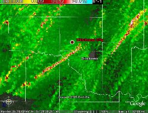
Rotation Tracks of mesocyclones
These pages have been designed and maintained by teams at NSSL and CIMMS at the University of Oklahoma.
DISCLAIMER: Use at your own risk. Data are experimental and may expirence any number of problems including
being late or not being available at all. Do NOT use for protection of life or property, or for any commercial use